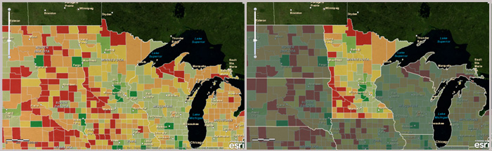
(Contributed by Owen Evans, Esri solution engineer). A mask is an effective way to make the area of interest in your web map stand out. For example, let’s say I am making a map of the projected population growth for Minnesota. There’s already a great population growth layer on ArcGIS Online, but it’s a nationwide layer. Adding a simple mask lets me customize my map and have it focus on just a single state.
You can quickly make a mask by publishing a feature service of states or any other type of region (countries, counties, sales territories, administrative regions, etc.). A feature service provides flexibility since you can adjust its symbols in the web map and also filter the features that are shown. Be sure to generalize the feature class or shapefile that you use for your mask so it doesn’t impact the performance of your web map.
Once you publish the feature service, filter out the feature(s) that is/are your area of interest. This will leave the other areas “masked out.” For example, here’s the filter used in the Minnesota example.

Next, adjust the symbols. One set of choices that works well are layer transparency at about 40%, a light grey border with a width of 2, and a dark grey fill (these are the settings used in the example above).
The best settings will vary depending on the symbols used in the other map layers as well as the basemap. You’ll also want to disable pop-ups on your mask layer and hide it in your legend. The mask should be a visual component of your map, but you typically don’t want it to affect these other aspects of your web map.

The feature service mask can easily be re-used in other maps. If you find symbol settings that you like, you can use the Save Item Properties option on the layer to save the symbol settings to the feature service item so that next time you add it to a map it will have those same settings. The final step is to share your mask layer with your organization or with everyone so that others can see it and find it to use it in their own web maps.
You can also make a mask layer with other types of services (e.g., tiled, cached, or dynamic layers services) and these could be hosted in ArcGIS Online or on your own GIS Server. Each service type will have different advantages or disadvantages over the feature service mask in terms of performance and layer drawing order, so try this technique out with other service types to see which one works best for your web maps.
For additional information see:


